PlaneSpottingWorld welcomes all new members! Please gives your ideas at the Terminal.
File:Chrome.JPG
From PlaneSpottingWorld, for aviation fans everywhere
No higher resolution available.
Chrome.JPG (554 × 364 pixels, file size: 60 KB, MIME type: image/jpeg)
| This image is licensed under the Creative Commons Attribution ShareAlike License v. 2.5: http://creativecommons.org/licenses/by-sa/2.5/ |
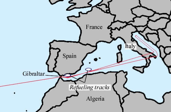
This aircraft navigational route is the Eastern section of a 15,000 mile, 26 hour, round-trip airborne alert from Miami, (HAFB), threatening six targets in The Soviet Union. Note the two air-refueling tracks near Spain. At the 22 hour mark, west bound, upon receipt of the "GO CODE", the B-52H remains capable of reversing direction and reaching at least the first target without additional refueling. Thereafter, assuming survival, the flight plan continues across N. Africa, Brazil, to recover the aircraft at Edwards AFB, California.
File history
Click on a date/time to view the file as it appeared at that time.
| Date/Time | Thumbnail | Dimensions | User | Comment | |
|---|---|---|---|---|---|
| current | 18:55, 5 March 2007 | | 554 × 364 (60 KB) | Admin (talk | contribs) | {{BadJPEG}} {{cc-by-sa-2.5}} This aircraft navigational route is the Eastern section of a 15,000 mile, 26 hour, round-trip airborne alert from Miami, (HAFB), threatening six targets in The Soviet Union. Note the two air-refueling tracks near Spain. At the 22 hour mark, west bound, upon receipt of the "GO CODE", the B-52H remains capable of reversing direction and reaching at least the first target without additional refueling. Thereafter, assuming survival, the flight plan continues across N. Africa, Brazil, to recover the aircraft at Edwards AFB, California. |
- You cannot overwrite this file.
File usage
The following 2 pages link to this file:
